Five Views of Old Innsbruck 1496-1750

DürerIBKSouth
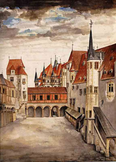
The Beau found a postcard in an old book, with this image of a painting by Albrecht Dürer. It shows the inner courtyard of the Hofburg in Innsbruck, or the “Hof der Burg”. I was immediately curious.
Because: you look at this and think, “Yeah, pretty, I guess. Long time ago.” I look at this and think, hang on, where was that crenellated wall? What’s there now? Can I stand in the same place? Will I recognize it when I see it?
Some searching revealed that the painter (and viewer) are looking south, and that another Dürer painting of the same courtyard exists, this time facing north. Neither view even remotely resembles what one sees when one looks into the large courtyard of the Hofburg today.
Mein Freund fand eine Postkarte mit dem Gemälde von Albrecht Dürer in einem alten Buch. Es zeigt den Innenhof der Hofburg in Innsbruck, oder der ” Hof der Burg ” – und das machte mich neugierig.
Denn, als ich das sah dachte ich: ” Ja, das ist ziemlich, vermute ich, lange her” und „Moment mal, wo war das zinnenbewehrten Mauer? Was ist da heute noch vorhanden? Kann ich an der gleichen Stelle heute noch stehen? Kann ich es erkennen, wenn ich es sehe?“
Nachforschungen ergaben, dass Maler (und Betrachter) nach Süden schauen und dass ein anderes Dürergemälde des gleichen Hofs mit Blickrichtung nach Norden existiert.
Keine der beiden Ansichten ähnelt auch nur entfernt dem, was man heute im großen Innenhof der Hofburg sieht.

Hofburg Nord
So, let’s take these two Dürer paintings and hold them up alongside his third Innsbruck painting, View of Innsbruck with Patscherkofel (mountain in the background), or, alternately, Innsbruck from the North. Also, nehmen wir diese beiden Dürer Gemälde und halten sie über sein drittes Innsbrucker Bild, der „Ansicht von Innsbruck mit Patscherkofel“ (Berg im Hintergrund), bzw. „Innsbruck aus dem Norden“.

durer-innsbruck

This watercolor painting, whatever its name, is pretty awesome, mainly because Dürer takes the Inn River and makes it into a lagoon, similar to Venice. In fact I think I see a gondola there on the water, no? Did Dürer forget where he was? Dieses Aquarell, wie auch immer es heißt, ist ziemlich genial, vor allem, weil Dürer den Inn zu einer Lagune macht, ähnlich wie Venedig. Tatsächlich meine ich eine Gondel auf dem Wasser zu erkennen, nicht wahr? Hat Dürer vergessen, wo er war?

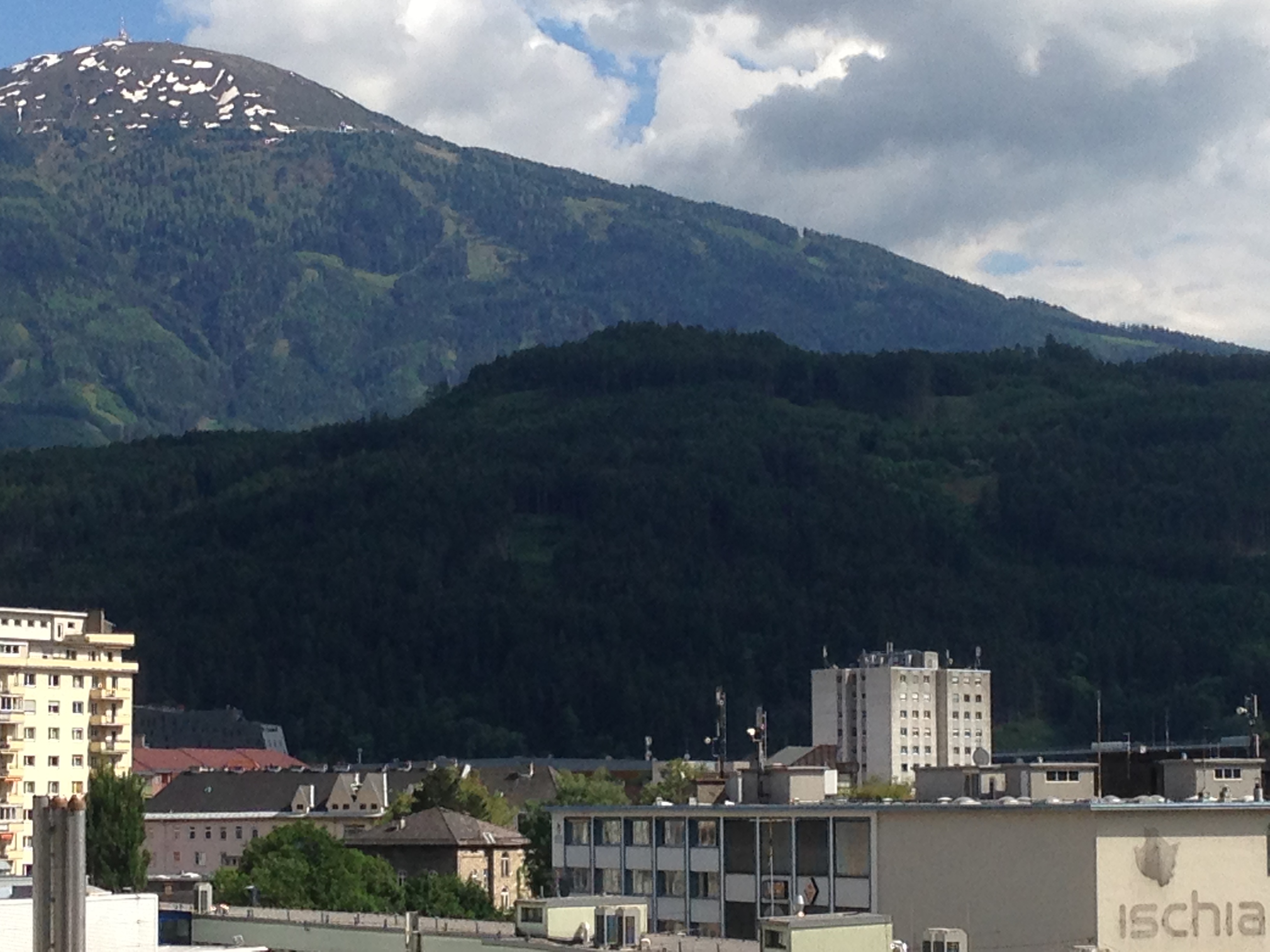
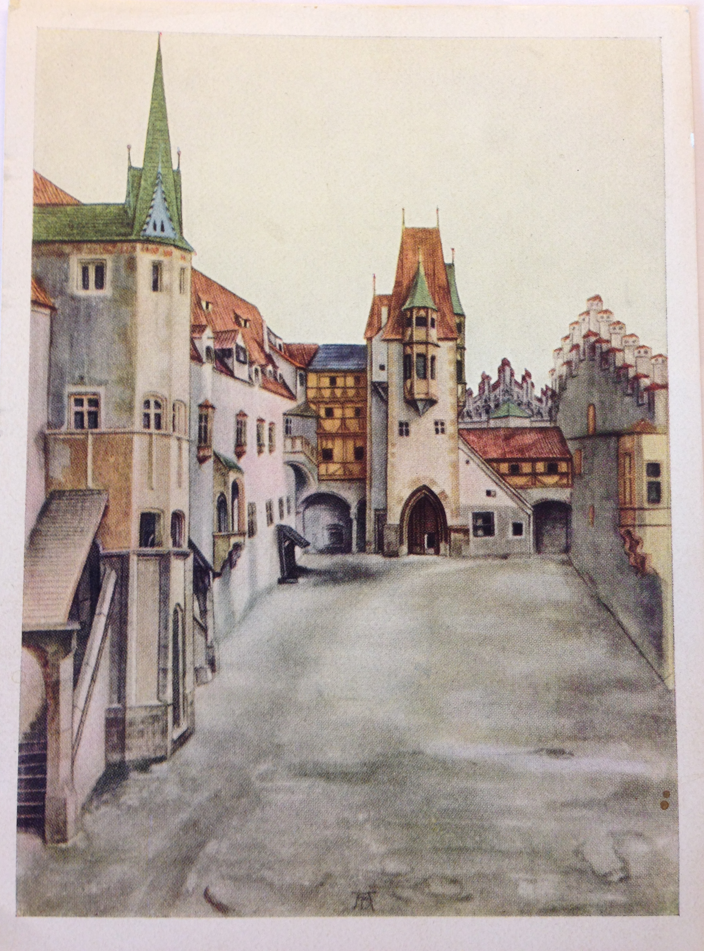
But no, it’s Innsbruck. This site (g) maintains that one can recognise the fortress’s tower, under scaffolding (as it would have been in 1496). The mountains, too, are local features. At first I took the snowy peak between the towers to be the Serles, but on second thought he may have meant the pointy Glungezer, with the rounded-off Patscherkofel just to its right. The white wall with the notches may be the same wall  in the first image (seen from the back on the right).
Aber nein, es ist Innsbruck. Diese Website) ermöglicht den Festungsturm unter Gerüst zu erkennen, (wie es im Jahre 1496 gewesen sein ). Die Berge entsprechend ihrer Eigenheiten herausgearbeitet. Zuerst nahm ich and die schneebedeckten Gipfel zwischen den Türmen seien der Serles, aber tatsächlich ist das die dem Glungezer vor gelagerte Sonnenspitze, mit der abgerundeten Patscherkofel zur Rechten. Der weiße Wand mit den Schießscharten könnte die gleichen Wand wie im ersten Bild (von hinten rechts gesehen ) sein.

Statt_Inspruck_(Merian)
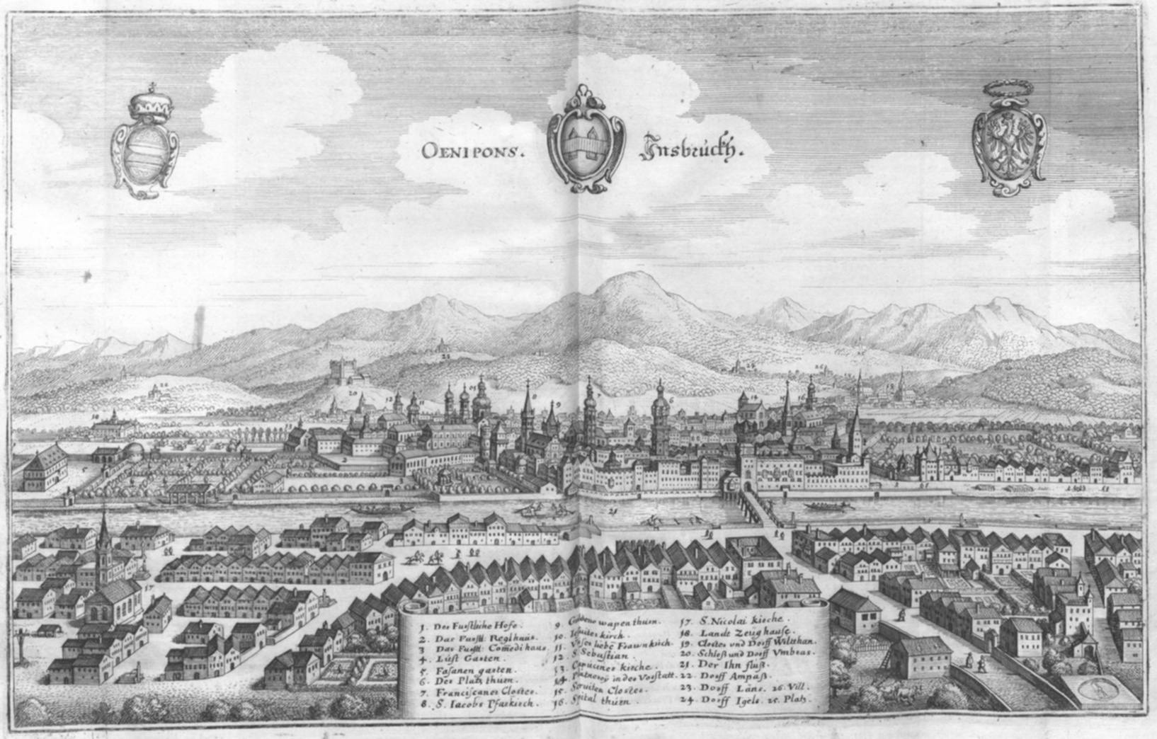
Here is a slightly later view (Matthäus Merian, Martin Zeiller: Topographia Provinciarum Austriacarum, 3. Ausgabe, Frankfurt am Main 1679) The Inn is depicted as considerably narrower, almost like a tubing ride at a waterpark, but I have to assume that the city itself has been portrayed more or less accurately. And now the Stadtturm is more prominent with its new “Zwiebelhelm mit Laterne” (onion-helmet with lantern, added in 1560).
Hier ist ein etwas später Ansicht (Matthäus Merian, Martin Zeiller, Topographia Provinciarum Austriacarum , 3 Ausgabe , Frankfurt am Main 1679 ) Der Inn ist deutlich schmaler dargestellt, fast wie ein Schlauchrutsche im Wasserpark, aber ich muss annehmen, dass die Stadt selbst mehr oder weniger genau dargestellt wurde. Zu diesem Zeitpunkt ist der Stadtturm mit seinem 1560 dazugebauten Zwiebelhelm mit Laterne etwas markanter.

IBKSketch
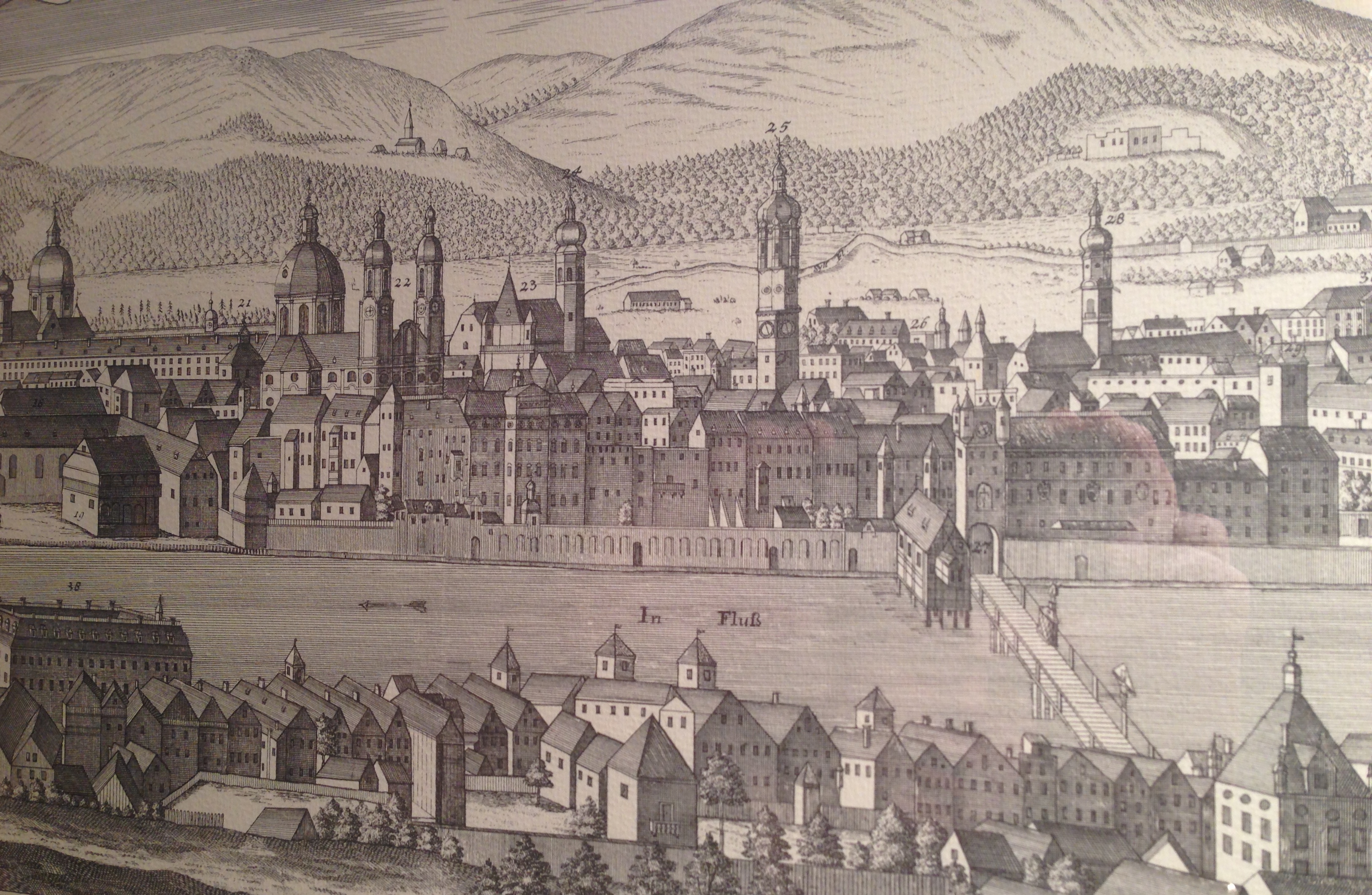
And here we have a copy of a sketch by one F.B. Werner, from 1750. (I photographed it off a friend’s wall, the reflection was unavoidable.) One sees that all the towers have been redone in the 250 years since Dürer painted here. My notched wall is gone, it seems. (Or maybe Dürer had taken artistic liberties?) The Wappenturm is still there, however, identifiable by it’s pyramid-shaped top above columns, just in front of the polar-bear-face facade of the Hofkirche. This tower stood (still stands) on the southeast corner of the Hofburg, with a portal which leads into Hofgasse. When the facade at Rennweg was completely renovated (1767-70), a second tower was built on the northeast corner, and both were made symmetrically round.
Und hier haben wir eine Kopie einer Skizze von einem F.B. Werner, von 1750. (Ich fotografierte sie an der Wand eines Freundes, die Reflexion war unvermeidlich.) Man sieht, dass alle Türme in den 250 Jahren, seit Dürer sie malte, erneuert worden sind. Meine Schießschartenwand (Stadtmauer — ed.) ist weg, es scheint. (Oder vielleicht hatte Dürer sich künstlerische Freiheiten genommen?) Der Wappenturm ist noch immer da, erkennbar durch seine pyramidenförmige Spitze auf Säulen (Eckerker — ed.), gerade vor der Fassade der Hofkirche mit dem Eisbärengesicht. Dieser Turm stand (und steht noch) an der südöstlichen Ecke der Hofburg, mit einem Portal, das in die Hofgasse führt. Bei der kompletten Renovierung der Fassade am Rennweg ( 1767 bis 1770 ) , wurde ein zweiter Turm an der nordöstlichen Ecke gebaut, und beide wurden symmetrisch rund gemacht.

We live in an old, medieval city, but in fact much has changed over time, even through the middle ages. Wir leben in einem alten, mittelalterlichen Stadt , aber in Wirklichkeit viel hat sich im Laufe der Zeit auch durch die Mittelalter verändert.

“gen de Kloas’n” / Klais*

IMG_1186

Teachers told us
The Romans built this place
They built a wall and a temple on the edge of the
Empire garrison town
They lived and they died
They prayed to their gods
But the stone gods did not make a sound
And their empire crumbled
Till all that was left
Were the stones the workmen found

— Sting, “All This Time”

The train from Innsbruck to Munich over Mittenwald stops in Klais, an unassuming alpine village of small hotels (for the tourists who come to ski in the winter and hike in the summer) and locals who probably work in Mittenwald or Garmisch-Partenkirchen. Last week I unboarded there to take a look at some  local attractions, one in particular.

IMG_1190First, along the small path called Römerweg (more on that in a bit), one comes across the Kirchfeld (church field), in which a boulder rests. This is the site of the old original Scharnitz Abbey (g), founded in 763 and whose monks moved to another area in 772. Excavations in the late 20th century found a church foundation, traces of living quarters, and a small graveyard. Just a minute further along the path, however, one comes to this:

IMG_1199

A path cut right out of the rock. This is what remains locally of the old Roman “Via Raetia”, which ran over the Alps via the Brenner Pass, Innsbruck, and then on to the Roman provincial capital Augusta Vindelicorum, now known as Augsburg.

IMG_1205
Above, a closer look at one of the grooves which helped determine, by the distance between them, that this road was used by Roman wagons and not wagons from the middle ages, when parts of this route were still very much in use.  (In researching this I stumbled upon a old tale which claimed that the US standard railroad gauge descends directly from the distance of the grooves left by “Roman chariots”. This story is false, for several reasons, but one of them being that the Roman army didn’t use chariots, which were so light that they wouldn’t have been leaving grooves anyway. The grooves come from plain old horse-drawn carts laden with goods, for army use or for trade.)

IMG_1200Römerweg ends here at this unpaved road, which leads to the main road back to Mittenwald. The Via Raetia probably does not lie beneath it, but rather somewhere hidden under pasture. Or maybe it does. One could cycle a bit of the general area of the road, although there is no fixed bike route as there is with parts of the Via Julia. The “Via Raetica Bike Path” is something else altogether, along the Danube near the Roman frontier. This online compendium of the Via Raetia would be useful in planning a route. Perhaps, with some deeper research and field work, I could publish my own someday…

*Ah yes, the title to this post.  A sign at the abbey site mentions, in the original documents pertaining to the dedication of the abbey, that the faithful of Mittenwald came to the church gen de Kloas’n [Geleisen], or “along the wheel tracks”. Although it has also been put forward that the village of Klais got it’s name from the Kloster, or even from the possibility of a clausura (military camp), the connection to the Geleisen seems to me the best answer.

AND: why you can’t walk/cycle a Roman road in it’s entirety. Note the lines indicating the tracks. Image from here (g).
www.kaluwi.de:Esch_Ech.html

Bergisel Jump (virtually) Revisited

Edited English-language intro: as the course for which I wrote this post is being offered once again, I have begun to remove references to it out of concern that someone will find this post via keywords and then just cut and paste. I would like for that not to happen.

2011 schrieb ich über einen Besuch bei den archäologischen Grabungen  an der Hinterseite des Bergisel. Ich habe diesen Beitrag nun hervorgeholt, um ihn bei meinem Archäologiekurs zu verwenden – um einen Fall über die Bewahrung von Funden zu beschreiben und zu zeigen, ob die Anstrengungen von Erfolg gekrönt waren oder nicht. Die Übung, diesen Beitrag nun in einem anderen Lichte zu schreiben, brachte mich dazu meinen bisherigen Ansichten zum Fundort und den Arbeitsschritten zu überdenken. Der Kulthügel am Bergisel ist eigentlich sowohl eine Rettungsgrabung alsauch ein Vermächtnis. Im Geiste der Teilhabe veröffentliche ich daher diese neue und verbesserte Version des damaligen Beitrags.

KoneSchanze

(Photo from  kone.com )

Bergisel is known today as the site of one of the “Four Hills” ski jumps (and a very nice one at that).  You may have seen the ski jumping competitions held here on television. The area is also used for concerts, New Year’s Eve fireworks displays, World Cup soccer match broadcasts on large screens, the annual “Air&Style” Freestyle Snowboard Festival, and is the location of the new Tirol Panorama Museum. There is also a pretty trail along the Sill Gorge, on the back side of the hill. It has, therefor, somewhat heavy human traffic at certain times during the year.
 Bergisel was also known to be a significant archaeological site since the 1840s, when a small military museum was built on a lower slope —the partial collection of a large treasure find is housed in the Tirol State Museum Ferdinandeum, the other part having been “carried off by the wagonful and sold by weight to bellmakers”.

Der Bergisel ist heutzutage bekannt als eine (besonders schöne) Station der Vierschanzentournee. Vielen wird der Bergisel von Fernsehübertragungen der Schisprungveranstaltungen bekannt sein. Das Gelände wird auch für Konzerte, Neujahrsfeuerwerke, Fußballübertragungen auf Großleinwand und dem jährlichen Air&Style Snowboard Festival genutzt. Zudem ist es der Standort des neuen Tirol Panoramas. Es gibt auch einen reizenden Steig durch die Sillschlucht, an der Rückseite des Bergisel. Der Platz ist somit im Jahreslauf zeitweise von Besuchern stark frequentiert.

Der Bergisel ist als herausragendes archäologisches Fundgebiet seit den 1840ér Jahren bekannt, da man damals ein kleines Militärmuseum am unteren Hangteil errichtete. Ein Teil der damaligen funde sind im Tiroler Landesmuseum ausgestellt, während eine anderer Teile als „Wagenladung weggeschafft und  nach Gewicht an Glockengießer verkauft wurde“.

Schanze BingAerialsketch

Top image is a screenshot from Bing Maps. Bottom image is from “Ur- and Frühgeschichte von Innsbruck” (“Prehistoric and Protohistoric Archaeology of Innsbruck”) catalog accompanying the 2007 exhibit at the Tiroler Landesmuseum Ferdinandeum, Innsbruck. In German.

When the old jump was built for the 1964 Winter Olympic Games, a large swath of earth had been removed, and a great deal of archaeological evidence unfortunately went with it. This jump was demolished in 2001 to make room for a better, modern one planned by the well-known architect Zaha Hadid, and in between local archaeologists from the University of Innsbruck were able to come in for a limited time and do excavations.
These excavations have uncovered a site for burnt offerings near the highest point of the hill, just a few meters east of the ski jump tower. Animal bones were found which had been burnt at a temperature of over 600°C.  These artifacts have been dates to ranging from 650 BCE to 15 BCE, when the Romans arrived, and would have been taken to the Ferdinandeum.

Als die alte Schisprungschanze  für die olympischen Spiele 1964 gebaute wurde, wurde eine mächtige Erdschicht und zugleich eine große Menge archäologischer Beweisstücke entfernt. Diese Schanze wurde 2001 abgetragen und durch einen besserer und modernere von der bekannte Architektin Zaha Hadid geplante ersetzt. Ein begrenzte Zeit konnten Archäologen der UNI Innsbruck Ausgrabungen durchführen.

Bei diesen Ausgrabungen wurden verbrannte Opfergaben nahe der Spitze des Berges, wenige Meter östliche des Schanzenturms entdeckt. Bei 600°C verbrannte Tierknochen wurden gefunden. Diese Fundstücke wurden Zeitraum zwischen 600 und 15 v.Chr., vor Ankunft der Römer, datiert und ins Ferdinandeum gebracht.

The features, that is, the larger artifacts, were then back-filled with earth and left alone.  There was absolutely NO information found (in 2012) at the site itself, which is on the outside of the fenced-in ski jump area, so one can’t just take the incline to visit it. There are barely trails — animal paths really — up the very steep grades on the back end of the hill. There are no signs forbidding access but it is difficult to get up there. ( I only made it up  —and down — by grabbing onto tree roots and watching very carefully where I stepped. Dead leaves, pine needles and pine cones added a certain hair-raising slipperiness to the adventure. )

Die Bodenmerkmale, also die größeren Fundstücke, wurden dann wieder mit Erde verfüllt und sich selbst überlassen. Es wurde absolut kein Hinweis auf den Fundort außerhalb des umzäunten Geländes der Sprungschanze hinterlassen, sodass man nicht die Möglichkeit hat, den Ort mit der Standseilbahn zu besuchen. Es gibt kaum Pfade den steilen abhängen der Hinterseite des Berges hinauf; die vorhandenen sind tatsächlich Trittspuren von Tieren. Es gibt keine Schilder, die den Zutritt verwehren, aber es ist auch nicht leicht dorthin zu kommen. (Ich selbst kam nur rauf –und runter – in dem ich mich an Baumwurzeln hochhantelte und genau achtete wohin ich trat. Alte Blätter, Nadeln und Tschurtschen (Föhrenzapfen) erweitern das Abenteuer um haarsträubenden Rutschigkeit)

OLYMPUS DIGITAL CAMERA

Photograph by the author.

The altar mound as seen today, on the highest point of the hill. The fence around the sport area runs right through the mound, which seems a little unfortunate. I do not know the impact of the fence on the re-buried site but hope that it is minimal.
My take on this site is that despite the great loss of artifacts from earlier landscaping and construction,  archaeologists have done their best to secure it and keep it removed from human disturbance as best they can.  They had been extremely pressed for time before construction on the new tower began. Today nearly all visitors experience the Bergisel at the lower end, where the Panorama Museum is located, or take the incline ride to the cafe  inside the ski jump tower (or walk up on the concrete steps) and have no interest in wandering over to the unidentified excavation site. This makes the conservation efforts  a success. A prognosis is more difficult, as I do not know what plans the property owners have for the area. As long as it remains as it is, the site is secure.[submitted summer 2013]

Der Kulthügel, wie man ihn heute sieht, liegt am höchsten Punkt des Berges. Der Zaun der Sportarena läuft direkt durch den Hügel, was etwas unglücklich erscheint. Ich weiß nicht, welche Auswirkungen das Zaunfundament auf die darunter vergrabene Fundstätte hat, hoffe aber, dass diese gering bleiben. Meinen Meinung über diesen Fundort ist, dass die Archäologen trotz der großen Verluste an Fundstücken durch frühere Geländeveränderungen und Bauarbeiten ihr Bestes getan haben, um das verbleibenden zu sicheren und vor menschlichem Zugriff zu bewahren. Sie handelten während des Baues der Sprungschanze unter großem Zeitdruck .

Heute erleben die Besucher den Bergisel vor allem am unteren Ende, wo das Panorama-Museum steht, oder fahren mit der Standseilbahn zum Cafe im Schanzenturm (oder gehen über die Stufen der Tribünen), haben jedoch kein Interesse über die unbekannte Ausgrabungsstätte zu wandern. Die sicherungsmaßnahmen der Archäologen sind somit erfolgreich. Eine Prognose ist hingegen schwierig, da ich die Pläne der Grundstückseigentümer nicht kenne. Solange es so bleibt ist der Fundort sicher.

Additional source link: http://www.uibk.ac.at/urgeschichte/projekte_forschung/archiv/archivprojekte-tomedi/03_02.html (in German)

Pagans In Tirol: The Medicine Woman from the Gurgl Valley

IMG_0632

I persuaded a good friend to drive me to the village of Tarrenz (in the Gurgltal, north of Imst) to visit the brand-new museum built to house a fascinating archaeological discovery there — die Heilerin von Gurgltal, which more of less translates as the “Medicine Woman” from the Gurgl Valley. Alternately she’s referenced as being from the Strader Wald, or from the forest in nearby Strad. The story in a nutshell:

Tarrenz lies along the Via Claudia Augusta, one of the old Roman roads over the Alps. Hobby archaeologists are attracted to this area because of the artifacts that can be found along old roads. Some such treasure-hunters were combing the woods with a metal detector, and came across the first signs of something very interesting and ultimately very mysterious.

Eine Freundin fuhr mit mir neulich nach Tarrenz (im Gurgltal, bei Imst), um das nagelneue Museum der Heilerin vom Gurgltal zu besuchen. (Alternativ ist sie die Heilerin vom Strader Wald gennant.) Tarrenz liegt entlang der historische Via Claudia Augusta, ein Ziel für Hobbyarchäologen, wegen der Menge von Artifakten, die man neben alten Strasse finden kann. Ein paar solche Schatzsucher waren vor einige Jahren mit einem Metalldetektor im Strader Wald; dort stießen sie auf einen interessanten und mysteriösen Fund:

IMG_0628

It was the grave of a woman, found lying face-down, along with a bounty of small and valuable objects — metal instruments such as scissors and keys, coins, pearls and crystals, a thimble, and — the headline-grabber —a set of metal cups used for cupping therapy. Dating places her having lived during the time of the 30 Years War, in the first half of the 17th century.

Das Grab einer Frau, in Bauchlage beerdigt, zusammen mit einer Menge kleine wertvolle Gegenstände — ihre Habseligkeiten. Eine Schere, eiserne Schlüssel, Münzen, Perlen, Kristallen, ein Fingerhut, und — meist interessant — ein Set Schröpfköpfe aus Metall. Hier der archäologische Befund. Die Frau lebte während der Zeit des Dreißigjahrigen Krieges.

IMG_0629

The circumstances don’t fit together in the usual way. She was buried quite far from the cemetery. A foreigner? A suicide? Possible Jenische*? She had, much like Ötzi did, her whole “professional kit” with her. Added to her grave as a kind of honor? Or thrown into it in a hasty burial? Then there’s the “face down” business, which normally is found to have been the custom for criminals. But she clearly hadn’t been executed as a witch, not with all those valuables in the grave with her, even though witch trials were very much in at the time.

Die Sachen passen nicht zusammen wie erwartet. Die Frau wurde ziehmlich weit weg vom nächsten Friedhof begraben. Eine Fremde? Ein Selbstmord? War sie Jenisch? Wie Ötzi, sie hatte ihre professionelle Werkzeuge dabei — wurden sie mit ihr mitbegraben, als ein Ehrenzeichen? Oder schnell hineingeworfen in Eile? Aber sie wurde gegraben mit Gesicht nach unten, wie man Kriminelle bestattete. Offensichtlich wurde sie nicht hingerichtet, sonst hätte man keine Grabbeigaben gefunden, obwohl die Hexenprozesse damals ganz in Mode war.

The museum tries to bring you in with carefully portioned experiences. First you hear  of the arts of healing as practiced in these parts, and how knowledge was handed down through generations. Then you learn about some actual cases from Tirol which involved persecutions due to superstition and fear. The antisemitic source — and consequences — of Anderl of Rinn is an example used.

Das Museum führt den Besucher vorsichtig in kleinen Etappen ein, vermutlich für die sehr junge Besucher. Man lernt von Heilkunde und wie das Wissen von Generation zu Generation übergeben wurde. Dann wird man gelehrt über wahre Öpfer von Aberglaube und Angst in Tirol, zum Beispiel die antisemitische Ursprung — und Folgen — der “Anderl von Rinn” Geschichte.

You are then ushered into to larger room to watch a short film combining the facts of the find (given by the head of the archaeology department at the University of Innsbruck, Professor Harald Stadler) with a dramatized version of what might have happened, using locals as actors. Their version involves a heathen midwife, banned from the community and the church (same thing back then) but nevertheless needed and called whenever someone got sick. A stillbirth is enough to have the villagers accuse her of witchcraft, and then tempers get hot, someone (guess who) gets killed, and a hasty, fearful burial is carried out in the forest. Entirely plausible — although often the truth is a lot more boring (she died of illness, her outsider travelling companion(s) buried her as best they could, and moved on?)
After the film ends, you finally get to see the skeleton and the artifacts, laid out under glass with plenty of information about their provenance and uses. The tour guides — a husband-and-wife team — are very much involved in the project and were able to answer questions in depth.

Man kommt dann in einer Halle und ein Kurzfilm läuft. Archäologische Details (von u.a. Universitätsprofessor Harald Stadler) alternieren mit einer Dramatisation von der Geschichte — also, was hätten passieren könnte — mit einheimische Mitwirkenden. In ihrer Fassung, ist die Frau eine Außenseiterin, eine heidnische Hebamme und Heilerin, aus der Gemeinde verbannt, dennoch in Krankenfälle immer wieder gerufen. Ein Totgeburt führt zur Vorwürfe von Hexerei, die Frau getötet und in Angst und Eile im Wald begraben. Alles schon möglich — obwohl die Wahrheit ist oft weniger interessant.
Dannach darf man den Skelett samt Artifakten (in Vitrinen) -endlich- sehen. Die Führer — ein Ehepaar — sind im Projekt involviert und konnte viele Fragen reichlich antworten.

If you go: the Museum der Heilerin von Gurgltal; is located within another, outdoor museum called Knappenwelt, which is a recreation of a small mountain mining industry from the olden days. You can buy a ticket for either, or in combination. Drive to Imst and then north on the 189 toward Fernpass. It’s trickier if you don’t have a car, but apparently this tourist shuttle will get you there from “downtown” Imst to the Knappenwelt. You’ll still have to walk from the Imst station, which is a bit removed from town.

Anfahrt: das Museum befindet sich in der “Knappenwelt”, ein Freilicht Museum. Von Imst kommt man mit dem Strasse Nr. 189 richtung Fernpass nach Tarrenz. Ohne Auto wird’s schwieriger, aber wenn man in Imst von Bahnhof ins Zentrum geht, findet man den Bummelzug “Bummelbär”, der macht einen Tour von Imst nach Strad mit Zwischenstops.

*Jenische is a name used for a certain nomadic people in Europe. They are not related to the Roma or Sinti — in fact they may not be an ethnic group at all but fall under the generic category “gypsy”.  Wikipedia likens their language to Cockney.

Lanser Kopf

The Lanser Kopf (“Lans Peak”)

 is  a rocky outcropping atop a wooded hill called the Paschberg, situated between Innsbruck, Austria, and the village of Lans. It sits just under 300 meters above the city, and a hike to the top can be done in about an hour.  It is one of the few lower hilltops which has not, to my knowledge,  been previously excavated.

Übernommen aus einem kürzlich verfassten Beitrag für einen Archäologie Online Kurs an dem ich teilnehme.
Der Lanser Kopf liegt auf dem Paschberg, zwischen Innsbruck und der Dorfgemeinde Lans, knapp 300 Meter über der Stadt, wovon man in ca. eine Stunde eine gemütliche Wanderung machen kann. Er ist eine der wenigen Mittelgebirgsebenen in der Gegend auf der man, so weit ich weiß, keine archäologischen Ausgrabungen durchgeführt wurden.

970259-51b733d484b3e5.86591292Innsbruck, Paschberg/Lanser Kopf, Patscherkofel (2246 m)

One of the most interesting things about the Lanser Kopf is that there are multiple of evidences of use over time. Schalensteine (rocks with cup markings) can be found on the lower slopes. Unfortunately it is impossible to date them. It is suspected that there may also be markings in the rocks at the peak, but these are partially covered with trees, earth and concrete. The concrete, poured in the middle of the last century, holds park benches and a marble table, and also makes up two WW2 Two flak circles. The circles were abandoned at the end of the war, and now have trees growing inside them.

Eine Besonderheit des Lanser Kopfs liegt in seine vielseitige Nutzung im Laufe der Zeit. Auf dem niedrigeren Hang findet man Schalensteine, die leider nicht datierbar sind.  Man vermutet, dass man oben an der Spitze auch Schälchen finden könnte, wenn die Steine nicht mit Erde, Bäumen und Beton verdeckt worden wären.  Der Beton wurde in der Mitte des vorigen Jahrhunderts am Kopf gebracht, um Parkbänke und eine runden Marmortafel zu befestigen, und wurde auch im zweiten Welzkrieg für die Herstellung von zwei Plattformen für Fliegerabwehrkanonen (FLAK-Kreise) verwendet. Bäume wachsen jetzt in den leer stehenden Kreisen.

970259-51b73492ce0f95.32446165Two WW2- era flak circles at the Lanser Kopf.

The earliest humans artifacts found in this region date back to about 30,000 BCE . Evidence of Bronze Age and Iron Age settlements have been discovered on other nearby hilltops, including stone residential terraces (Hohe Birga, Himmelreich), and sacrificial burning sites (Goldbichl, Bergisel.)

Die älteste prähistorische Artefakte aus dieser Gegend datieren auf 30,000 v. Chr.  Neolithische Siedlungen hat man an naheliegenden Hügeln entdeckt, Steinterrassensiedlungen (Hohe Birga, Himmelrich) und auf Brandopferplätze (Goldbichl, Bergisel).

As far as I know, the Lanser Kopf was not used for anything in the Modern Era — with the exception of the wartime use — other than as a place to rest while hiking. There is no obvious evidence of it having been used for farming or settlement. However, it’s use in the last century as a strategic point for sighting enemy planes and firing missiles at them certainly would have roughed up the area somewhat, since it can been assumed that military jeeps or trucks would have been driven at least to the plateau just below the flak circles, and the construction of the circles themselves would have affected any older formation processes.

So weit ich weiß hatte der Lanser Kopf in der jüngeren Geschichte, außer während der Kriegszeit, nie eine besondere Funktion. Es gibt dort keine offensichtlichen Anzeichen von Siedlung oder Landwirtschaft. Er diente als Rastplatz für Wanderer.  In den Kriegsjahren war die Gegend mutmaßlich von LKWs und Jeeps überrollt, und die Herstellung der FLAK -Kreise hätte ältere Spuren zerstört.

This, however, brings forward another question — which kinds of artifacts does one wish to find? There may well be modern(ish) war artifacts in the vicinity, from either the Second World War or from the battles against Napoleon’s troops in 1809. There may be man-made objects just below the surfaces. 
But could be there also be older signs of human settlement below the flak circles? One would unfortunately have to destroy them in order to see what lies below. And while the concrete flak circles may not be of much interest to people today, I find it important that they remain, as an historical testament to Innsbruck’s war involvement in the 1940s. I find that it would not be worth it to remove them in the search for earlier artifacts. The earth-covered level area just below them, however, would be a worthy site for excavation, indeed if such work hasn’t been done already.

Das alles wirft eine Frage auf:  Welche Artefakte erwartet man zu finden? Es gibt wahrscheinlich schon genug Kriegsartefakte aus dem zweiten Weltkrieg oder, weiter zurück, vom Tiroler Volksaufstand in 1809.  Könnten prähistorische Funde direkt unter den FLAK-Fundamenten liegen? Man müsste diese aber zerstören, wenn man dort richtig graben will. Obwohl sie heutzutage wenige Leute interessieren,  würde ich lieber sehen, dass sie intakt bleiben, als historische Zeitzeugnisse der Kriegsjahre Innsbrucks. Hingegen läge auf der kleinen Ebene etwas unterhalb der kreisförmigen Fundamente eine angemessen Stelle für eine Ausgrabung, wenn nicht solche schon durchgeführt wurden.

From evidence gathered by archaeologists, pre-Roman-era settlers in Tirol greatly preferred the high plateaus and hilltops between the Inn (swampy floodplain) and the mountains (rocky, barren). This middle ground was probably ideal for hunting as well as providing safety. Since the arrival of the Christian missionaries in the Middle Ages, many of those hilltops have been adorned with chapels. It has been speculated  that these  chapels might be sitting atop the remains of pre-christian structures, and often successful excavation work has been done in their immediate vicinity.  If such an excavation were done on the Lanser Kopf, one might look for pre-historic arrowheads, ceramics, stone objects, weapon depots and offerings (of which there are many in the Alps) or sacrificial burning sites, all of which have been found elsewhere in the region.

Aus archäologischen Befunden in der Region wissen wir, dass viele vorrömische Siedlungen in den Mittelgebirgen eingerichtet wurden, wo die Ureinwohner mehr Sicherheit und bessere Lebensqualität vorfanden. Seit der Ankunft christlicher Missionare im Frühmittelalter, sind viele dieser einigermaßen höheren Stelle mit Kapellen geschmückt.  Man könnte vermuten, dass manche dieser Kapellen möglicherweise auf Resten von früheren, vorchristlichen Bauwerke stehen, und tatsächlich hat man neben solchen Kapellen erfolgreiche Ausgrabungen durchgeführt. Wenn man so eine Ausgrabung auf dem Lanser Kopf unternähme, fände man möglicherweise Artefakten wie Pfeilspitze, Keramik, Steinfiguren, Waffendepots oder Brandopferstätte, welche anderswo in der Region, auf höheren Stellen, bereits gefunden wurden.


The Viereckschanze in Utting

UttingSchanze1

I previously blogged about the village of Utting am Ammersee in connection with the small, hidden cemetery for nearby concentration camp victims there. Today I have another unusual place to show you — the rectangular earthwork (Viereckschanze) in the fields just west of the village.

Uttingschanze3

This earthwork was built around 200-100 B.C., in the late Iron Age, by the people we call Celts. According to local sources the Roman Via Raetia (laid down after 15 A.D.) passed right by here, possibly within a few meters of the earthwork.

UttingSchanze2

There are approximately 150 such earthworks of this kind (not including grave mounds and other types) surviving in whole or in part today in Bavaria alone. The one in Utting is one of five in the county, and an unusually large one with an inside area of 12,000 square meters.

Uttingschanze4

According to information given on-site, research of some kind (a divining rod is mentioned) has revealed evidence inside the enclosure of the existence of A) small buildings, B) a sacrificial site, C) a hole with wooden support walls.

I have to add here that the western side of the Ammersee, we are learning, is some kind of hotspot for the esoterically-minded, and evidently has been for quite some time, as least as early as the 1920s. The sign at this earthwork clearly reflects this, with breezy assertations that the small buildings were temples, the hole was for divining energies, that the whole thing was primarily used for “cult-religious purposes and activities, teaching and passing on of traditions, adjudication, observance of nature and the heavens.” It goes on to say that

the Celts lived in close harmony with the laws of nature. They sensed unseen active entities, forces and energies. They built their ritual sites on places with particular characteristics. These phenomena can evoke internal visions, colors, sounds or moods even today in people who are especially attuned to listening to them.

(translation mine)

Now, there may be something to the idea that people of all eras feel a certain affinity to certain places. I have come across some theories that medieval churches were built on pagan sites not just to wipe out the old gods but to capitalize on the good vibes attributed to the particular place. That’s plausible. Certainly the Celts were more in tune with the laws of nature, as were all people living at the time. But the idea that these earlier people had time to spend tuning into the universe, observing nature and digging the force fields is, to me, a bunch of hooey. Sure, this Schanze may well have included some religious purpose, in the sense that one might feel the need to pray to one’s gods while barricaded inside. These earthworks offered protection, possibly against invaders, or animals (bears, wolves, wild boars). They offered a good surveillance view of the surrounding lands. They offered safe places to keep foodstuffs and materials (leather, bone, wood) awaiting processing. Sure, the Mayans and the Egyptians built pyramids (or, better said, their kings and pharoahs made them do it.) I cannot believe  that the Celts were not too busy, just from trying to get through the winter, to expend time and energy on this sort of thing for the express purpose of being One With The Universe. Perhaps they had one Shaman who did that, and it was built for him (or her.) But then, we are back to today’s system, with a village of farmers and one parish priest. Perhaps the most powerful families maintained these enclosures, like an Iron-Age version of the Kennedy Compound. Many large farms around here have their own little chapels on their grounds (in fact you can have one built these days — we watched one go up in Eching, passing that farm regularly.) Since we are walking around today with basically the same faculties as our ancestors had 50,000 years ago, I see no reason to believe that the people who built the Schanzen were any more enlightened than today’s modern Bauer.

Still, it’s quite something to be on an earthen structure which has survived over 2000 years.

If you go: you can find the earthwork very easily on Google Maps (WNW of Utting, no coordinates needed:just  look for the word “Keltenschanze”). There is parking just off the ST2347 (Landsberger Strasse) and then it’s a few minutes walk on well-maintained gravel roads.

“At The Roman Stone”

IMG_0493

This post’s title is the translation of Am Römerstein, a street in the Bavarian town of Gilching. It’s a road the Beau takes regularly for business. The name always intrigued me — where is, or was, this Roman stone, anyway?

Gilching

A look at a map of Gilching shows that Am Römerstein intersects (and for a short stretch follows) the old Roman road Via Julia from Salzburg to Augsburg (through Gilching it is named, appropriately, Römerstrasse. Click on the link above to see a simple map of the entire road. Gilching is on the red line just above the area between those two lakes.) So the street got it’s name from being at or near a milestone on the Roman road. Salzburg, not yet the summer destination of the Euro-chic, was important for it’s salt mines, salt in earlier times being a very valuable commodity. (Worth another blog post at a later time. The names of many places in Germany and Austria come from their importance in the salt trade.) Augsburg was Augusta Vindelicorum, the capital city of Roman province Raetia and all the Roman roads in and around the Alps lead not to Rome, but to there.

Back to my milestone. With the help of Zeitspringer (who blogs chiefly about archaeological outings in Bavaria and Baden-Württemberg, and who is a great source of information on the subject, his blog is well worth perusing if you read German), I learned that a stone erected in the 1860s and dedicated to the Roman Road is included in a list of monuments on Gilching, including it’s location. A trip over there brought us to Number 15 Am Römerstein, where we found this monument,

IMG_0491

Roman Road
from
Augusta Vindelicorum
(Augsburg)
to
Juvavum
(Salzburg)

This, by the way, is definitely not the same stone mentioned (and shown) in Gilching’s Wikipedia entry (g), a small tube-shaped stone with engraved Latin text, a copy made more recently than the monument at 15 Am Römerstein. So where is the milestone photographed and shown in the Wikipedia entry? Turns out, it’s just a bit further down the road (g), in the center of town.

I assume that the street Am Römerstein, therefor, is named after the 19th-century monument to the Roman road, and not for the site of the Roman milestone (although it’s also entirely possible that the former was erected on the actual site of the original, and the later copy was placed somewhere more convenient and available.) A sign erected near the copy stone gives a very interesting account of the original’s fate. Milestones have been hauled off and used as building stones since the Late Antiquity. This particular stone was taken to Hattenhofen (there are four communities in the area with that name, most likely they mean the one in Fürstenfeldbrück County) in the 16th century, and then used as a cornerstone in Günzlhofen Castle. After the castle fell to ruin it came it Munich, first in the Royal “Antiquarium” and later as part of the Bavarian national collection of prehistoric artifacts, and exhibited with it. Here is where it met it’s ultimate fate, on a date with an Allied bomb in 1944.

Weapons For The Gods

The Ferdinandeum (our provincial museum) is hosting an exhibit of early sacrificial offerings found in and around the Alps for military purposes (g*).

This is evidently something that people did over millennia — gave up offerings of weaponry and other war accessories for battles won, enemies routed or eliminated. The museum stresses that one not only can learn about the conquerors but also about the conquered by the qualities of their weapons.
The exhibit includes many artifacts recovered from Fliess, depots of bronze helmets, shields, swords and daggers, stone axes, Roman figurines. There are also some items on loan from the National Museum of Slovenia, recovered by this man, whose mission in the last several years has been to save the Ljubljanica River’s tens of thousands of treasure from diving treasure hunters and rich collectors. Moreover, that sword in his hand (or one very much like it) might be in the exhibit.
The time frame spans from early pre-historic stone items through the Celtic ages and into the Roman occupation, as the Romans did this as well.

* If you click on this link and then download the pdf “Rahmenprogramm” at the bottom, there is some additional information available in English and Italian.

Archäologisches Museum Fliess

Impressions from a recent visit to the Archaeological Museum in Fliess. It is actually two museums: one part displays the archaeological finds associated with the pre-historical sacrificial burning sites (1500 BC – 200 AD) and treasure hoards found in the surrounding mountains, the other displays artifacts connected to the Roman Via Claudia Augusta which runs right through the area.

The finds at a Bronze-Age sacrificial altar site include many metal swords and tools, prepared for the spirit world by rendering them useless. Above, swords which had been chopped into segments in order for their “essence” to be sent up to whichever god they was meant for.

One of the oldest metal helmets ever found in Europe — it’s native, Hallstadt Culture, not Roman. It too had been cut apart and bent, one assumes in preparation for sacrifice. The three double blades on the top would have held horse hair a plume.

The level of detail and aesthetic beauty is impressive.

Celtic coins, minted sometime between 150 BC and 200 AD, and probably somewhere between southern Germany and Burgundy. At least two of them (top row, second from left and bottom row, second from right) are Büschel or “tuft” coins; instead of an entire head in profile which is found on many Roman, Greek and Gallic coins, these seem to zoom in on a few locks of hair. The discovery of a cache of old coins can bring one’s thoughts right into the time when they were hidden. Unlike a collection of offerings which may have grown over time, they were probably buried all at once, possibly in a dangerous time and certainly with the hope of retrieval. Something went wrong, and they were forgotten, until found thousands of years later.

The game we call “jacks” is also known as “knucklebones”, and is a very old game indeed. The ancient Greeks played it, and it had certainly been around for a long time already by then. The bones used as game pieces are actually astragalus or talus bones from the ankle.

The Archaeological Museum in Fliess is open from May through October. We were fortunate to have an informed and helpful guide who stayed past closing time in order to give us enough time to see everything and to answer our questions. The museum also runs a small press for the publication of literature on the archaeological finds from the area.

Fliess!

I dragged a (quite willing) friend along with me on a day excursion to Fliess (around here written Fließ), a village up on a mountainside overlooking the Upper Inn Valley. The main reason was to visit the Archaeological Museum, home of an impressive number of Roman and pre-Roman objects found in the area. While we enjoyed the Museum immensely, the journey there offered a surprising number of delights.

We had planned to take a Postbus from Landeck, but were given some misleading information (we had not realized that we were to take the bus that passes in the valley below, and walk up from there) and so we decided to walk rather than wait, and to take the trail over Landeck Castle. Without planning to, we found ourselves on the old road bed of the Via Claudia Augusta, the Roman road which ran along a portion of the Inn River on its way to Augsburg. The “Claudia” part is for Emperor Claudius, who had it built. His father Drusus, adopted son of Caesar Augustus, was responsible for the Roman march over the Alps and into northern lands.

Heumanderl, or hay racks, in a field. My friend told me a legend about our local hero Andreas Hofer using these “hay men” to make Napoleon’s troops think he had a larger army than he had.

Dramatic Squirrel has an Alpine cousin — and he’s black.

Another reason to come to Fliess was to see the Schalenstein at the Philomena Chapel, just outside the village.

The chapel was built in or around 1749. Inside, directly behind the altar hangs a painting (with reliquary) of the virgin martyr Philomena, “lying in her grave in the catacomb”, according to the information plaque on site, although she appears to be quite comfortably settled in a chaise longue. Philomena is one of those quasi-saints who were not only never canonized, but who was purged from the liturgical calendars in 1961. Her golden pendant is a reliquary for something so tiny that we could not make out what it was — possibly a bone sliver?

Ah, and here, finally, behind the church, the Neolithic Schalenstein with 70-90 markings, one of the most prominent of its kind.

A post on the Archaeological Museum to follow shortly.