Romans in Bavaria: comparing two online archeology maps for one specific area

Zeitspringer has a post up (in German) about the Roman road which ran between Augsburg and Salzburg, an important salt route referred to today as the “Via Julia”. Evidently there is a bit of uncertainty about the point where the road crossed the Isar River south of Munich. In his post, Zeitspringer mentions the site Vici.org, which I hadn’t known about before. Like the Bavarian Monuments Atlas (also in German), this site superimposes archeological sites—as well as presumed routes of Roman roads—onto satellite maps. I love these kinds of maps, and they have been an enormous help in finding things when you’re on the ground and need landmarks for orientation (with these maps, even a lone tree in a field—something you won’t find on a conventional map—can tell you something).

Well, most of what is known about the routes of these Roman roads north of the Alps comes primarily from 1) ancient (but still after-the-fact) maps, 2) excavated finds and 3) common geographical sense, particularly over the passes where there really wasn’t much choice about where to travel (see Scharnitz, in Tyrol). But as far as where-exactly, to the meter precision, it’s really only 2) that can provide any kind of accuracy, and only then at those points. The lines between those two points often must be assumed (unless they come up out of the ground, making for excellent aerial photography).

Wiel_Raisting_google

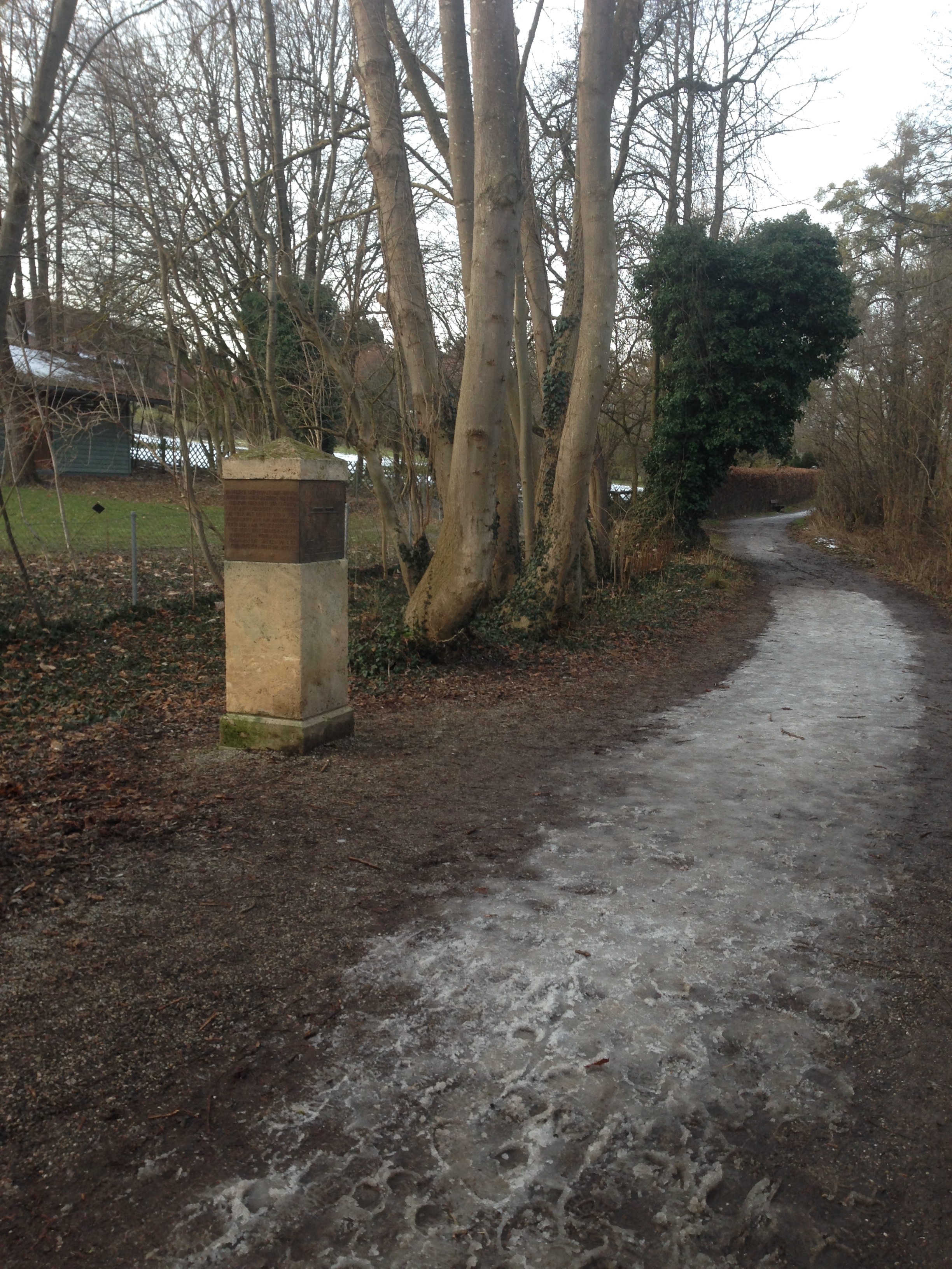
Anyway, I was curious as to what Vici.org had to say about my Roman road, the Via Raetia, which runs along part of the western shore of the Ammersee. Knowing that these things can’t be anywhere near 100% accurate, I was still a bit surprised to see where they put the line.

Vici-Raetia-Utting

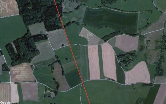
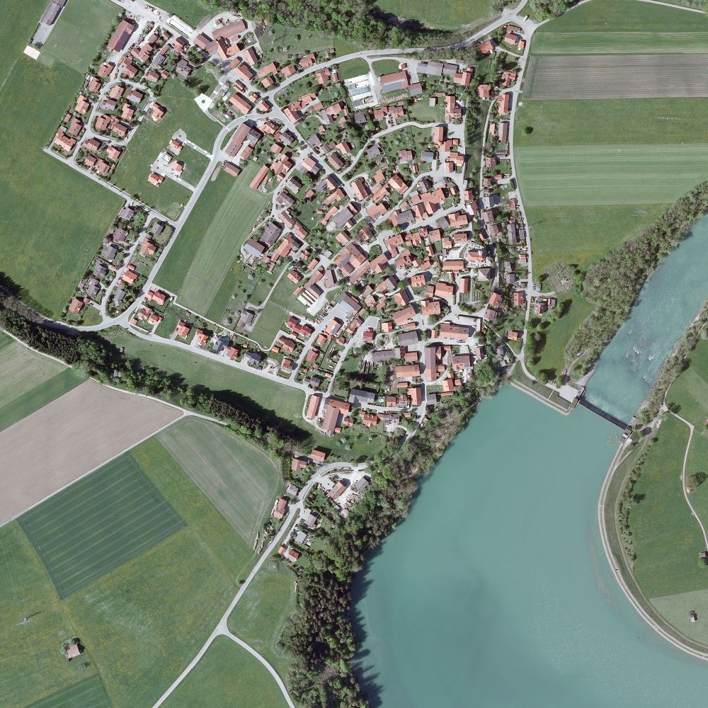
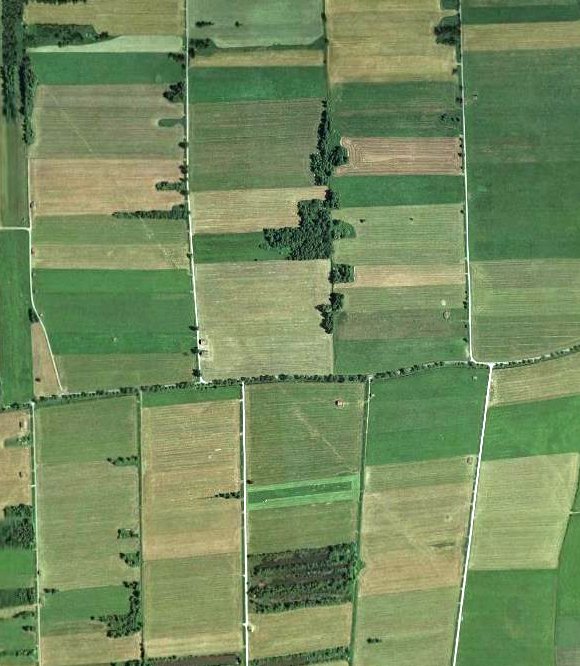
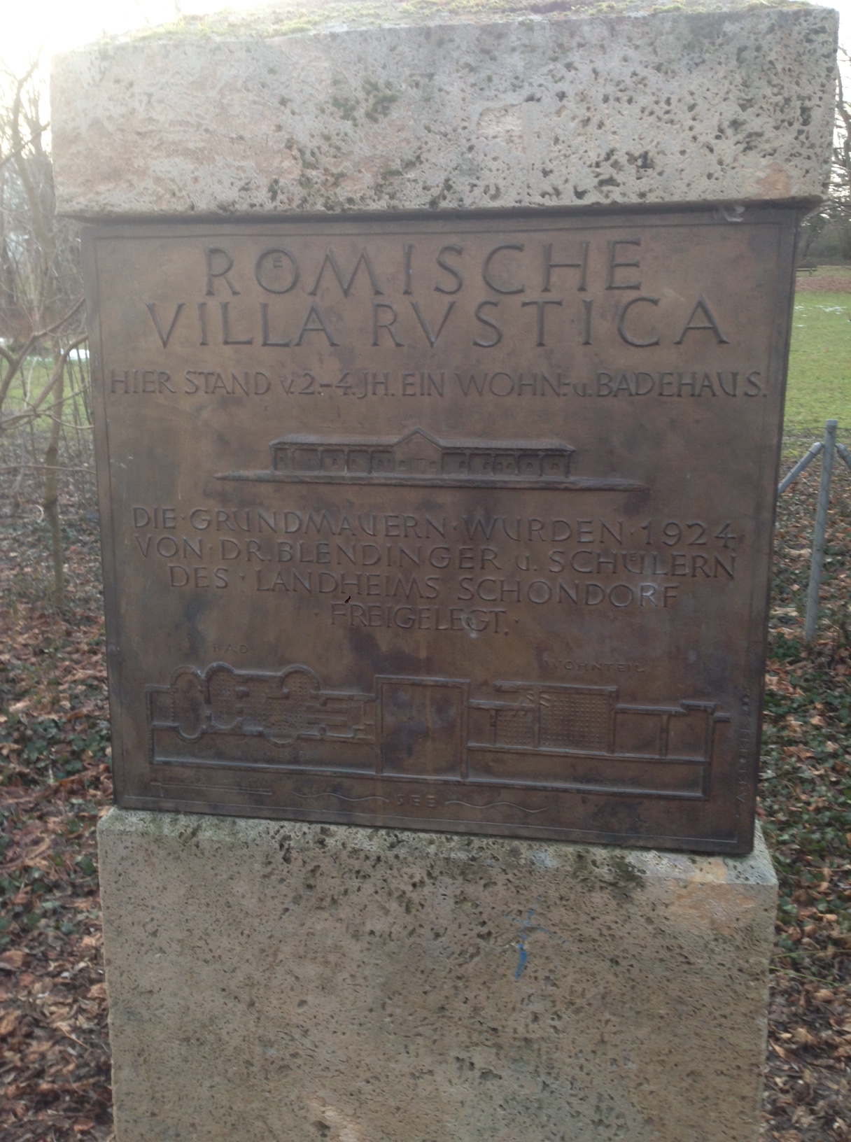
The aerial photo above is of the area west of Utting, south of Achselschwang. We know this area well because we often take walks here; it’s hilly terrain, unlike the flat fields in the photo above it. The Roman road, according to Vici, is the red line through the picture. However, can you make out that faint quadrilateral shape intersected by the line, with trees at three of its corners? That’s an old Celtic Viereckschanze, a four-sided earthwork that pre-dates the Roman road, and I have difficulty believing that the Romans would have simply built a road through it (although I suppose anything is possible, theoretically).

BDA-Utting-Schanze

Above is a screen grab of the same area (the Viereckschanze is in the center, marked in red). Here, the Via Raetia runs a good 200 meters further west, and, knowing the terrain quite well there, I am more likely to believe this. What’s more, it joins the present road at Achselschwang. That means little on its own, and I am certainly no expert, but Achselschwang first gets a mention in records in the year 760. Its beginnings might go back to an old straight(-ish) track that had been used for hundreds of years, why not? When the Romans retreated from the regions north of the Alps, they left behind quite a few “Romanized” locals whose descendants would have kept using the paths, just as they  pulled out Roman gravestones for early stone churches (like the one in nearby Leutstetten, a place discussed here before). Those roads carried pilgrims to Rome, and traders, and early travelers like Albrecht Dürer (who visited Italy twice), and some parts of the old Via Raetia are still part of the national road network, albeit under lots of asphalt. In other words, they left traces.

Weekend Mountain Rail Blogging

img_3149

The Mittenwaldbahn meets the trail at the Seefelder Sattel. Photo shamelessly purloined from Martin Schönherr.

Tyrolean omniscient and Friend of the Blog Paschberg sends a photo of greeting from the Seefelder Sattel, a little pass over the most easily navigable part of the Karwendel Mountains, and known as a point along the alignment of the Via Raetia. What he may not remember is that I myself have a similar photo, previously posted here, from pretty much the same spot, but looking the other way — the thing is, I had indeed been looking for the Seefelder Sattel, but didn’t realize that I had been standing right on it until now.
IMG_1999

In a somewhat related vein: the closed railway line which ran past my recent overnight accommodations in Passau’s Innstadt.
img_2830
It turns out to be part of the former Passau-Hauzenberg Railway, now used primarily by dog walkers. (The Beau, charmingly sarcastic as ever, suggested that it had probably been left behind by the Romans.)

In Via: Raisting

*img_2278

If one is interested, as I am, in the routes of the Roman roads in southern Bavaria, then one has probably heard of Raisting; the north-to-south road from the Brenner Pass to Augsburg (Via Raetia) and the southwest-to-northeast road from Bregenz to Gauting intersected here. Evidence of the latter road can be found further west, but the former has left traces in the land here which can be seen from the air. I wanted to find out what can be seen from the ground, and I wasn’t disappointed.

img_3123

First one travels south of Raisting, to the field of giant satellite dishes belonging to the German Postal Service. Our starting point will be this church.

img_2279

The old pilgrimage church St. Johann is supposedly the oldest church in the area, founded in the time of the first Christian community in Augsburg. This thesis is based on the fact that the old Roman Augsburg-Brenner road lay just 100 meters west of it.
According to legend it was built “on a holy place” by Tassilo III (748-788), the last Agilolfinger Duke. Tassilo, so the story goes, got lost on a hunt in the woods between the Lech and the Ammer rivers. He swore that when he figured out where he was, he’d build a church on the spot. Eventually he reached an open space from which he could make out the lake, and that is where Tassilo built his promised chapel. The altar was placed over a spring. (A church on a “holy place, built in the region’s earliest days of Christianity, with the alter over spring, near the Roman road? That sounds suspiciously like the former site of a roadside pagan temple.)

img_2281

It was especially cold last week; the welcoming committee was surely happy to soak up the warm sunshine today. Our instructions were to follow the road past the church until the second ditch, and then look southeast into the field. And lo…

img_3122

It’s difficult to see in this picture that the ribbon stretching before us is slightly raised, but it is easier to tell its presence by its lack of snow — underneath lies the pebble road bed. We left the marked road and trekked into the field.

img_2285

And met up with a barbed wire fence. Which didn’t stop us, we slid over /under it and followed the track to the end of the field, observed only by a small herd of camera-shy deer. Here the road alignment is even clearer to the eye. There is supposed to be the remains of a peat cutting ditch in the strip of woods straight ahead, but we saw only a small border stone marker poking out of the deeper snow before turning back.

img_2295

The satellite facility is surrounded by farmland and is easily accessible. It was impressive to see them up close. With the Via Raetia, St. Johann church and the satellite dishes, we had 2000 years of human achievement presented before us in one short walk.

img_2296

And here the route of the Via Raetia is still in use, as the main road through Raisting and Diessen, after which it veers slightly westward on its way toward Augsburg. The next place to trace its route is in Achselschwang, which we documented back in May 2014. It has since become a regular walking route for us.

Soviodurum, and a Mysterious Stone Object

img_2757

Roman knee and shin guards with intricate details

I had the chance to visit Straubing, a small town along the Danube in Lower Bavaria – basically I was there on business, but arrived a few hours earlier in order to see the Roman exhibit at the town museum. As Straubing (Soviodurum) was along the Limes and had a military station there, the museum had quite a bit to offer. Perhaps not as much as Passau or even Fliess in Tirol, but a nice exhibit nonetheless.

img_2758

Head protection for Roman horses

img_2760

Roman glassware found in Straubing, Bavaria

I had never considered whether the Romans used glass, since so often one sees only ceramics. The designs are downright modern.

img_2762

A stash of coins hidden before the collapse

This found stash of coins, like many others discovered south of the Limes, reminds one of how it ended: things looked bad, treasures were buried, things indeed got very bad, and the owners never returned to the site to reclaim their property.

The photo below was made earlier and is not from Straubing. Knowing that I was going to be spending some time in Lower Bavaria, I had done a little advance research for any mention of early, pre-Roman history of the area, and stumbled across a fleeting reference to a schalenstein in the Passau Rathaus from 1899. ( I did wander a bit through the public areas of this town hall, but did not see anyone who looked like they might know what I was talking about if I should ask.) Later, however, I took a walk up to the fortress overlooking Passau and came across this.

img_2616

What could this be?

Which is, well, technically, a schalenstein (it’s stone, and it has cup markings)
but to me looks more like something made much later. There are what appear to be charcoal markings inside. It is simply built into the wall in one of the towers, with no explanation.

Circumitus: Batavis, Boiodurum

IMG_2540

(The name actually refers to the bicycle route and is not, apparently, what the Romans called it.)

This posting hails from the other side of Bavaria, a “detour” onto the Roman road which follows the Danube and also the boundary separating the Roman Empire (in this case, the province of Raetia) from the Germanic Marcomanni to the north. This border is known as the Limes, and covered the lands on all sides of the Mediterranean Sea, in one form or another.

IMG_2542

The Roman Museum in Passau is built on the site of one of the fortified structures from the Roman period, Boiodurum. This name, like many Roman sites in Germany is apparently of Celtic origin. There were people settled on Passau’s peninsula long before even the official founding date of Rome, but according to archaeological finds they were gone, or least no longer present in sufficient numbers (discontinuity), by the time the Romans arrived; no signs of destruction or conflict have been found either. This brings me to something I have been thinking about ever since I started looking at early European history: the way some history texts tell it, the reader can get the impression that the Romans simply arrived one day –  cutting through virgin land with their swords and putting down roads to get to their provincial capitals which had also just appeared out of thin air. Just as there had been settlements here before, and some infrastructure (mule paths over the Alps), there surely must have been some Roman presence here long before as well, even if only in the form of tradesmen or scouts. Polybius made remarks about the Raetians over a century before the transalpine road plans went into effect.

IMG_2561

The museum found a creative way to present the Tabula Peutingeriana in a large enough size to actually read it.

There were plenty of Roman soldiers in this “three rivers” area, but other people as well, judging from excavation finds. Below is a type of “diploma” awarded to a Roman soldier after completing his 25-year service (if he survived that long). He got some money and a little set of engraved dog tags, threaded together with wire like a spiral notebook, according him privilege wherever he went. Did Claudius Paternus Clementianus of Epfach possess one of these? Probably.

IMG_2563

IMG_2549

Part of a roof tile found in the ruins of the Roman Boiodurum fortress at Passau, delightfully marred by a paw print before it was dry.

In Passau one may find a little light shed on the continuity of the place after the Romans withdrew. Roman troops at Boiodurum were among the last to stick it out along the Limes, after other frontier posts had already fallen. Eugippius says that a small group set out for Rome to collect the soldiers’ last pay but were killed by Barbarians, unbeknownst to those remaining and waiting for their return. Eugippius’ biography of St. Severinus mentions “people” – probably both Romans and Romanized Raetians – holing up together in Batavis (the fortified Roman settlement in Passau, on the hill where, not coincidentally, the Cathedral now stands) and defeating the invaders before being urged to leave for safety at Lauriacum (Enns). Eugippus also mentions St. Severinus founding a small monastery at “Boiotro”, most certainly using the existing Boiodurum fortress walls.

IMG_2572

A last sign of the Roman Empire’s long march toward being the Holy Roman Empire: not St. Severinus, but the Holy Bishop Valentin of Noricum (Roman province of Salzburg), who came to Raetia as a missionary. The silver box below his image is said to hold his relics. My understanding of the “Dark Ages” seems to have been a little wrong until now – it was certainly chaotic, violent,  in flux, and certainly dark to live in — but not completely shrouded in misty Unknown. The information is there, you just have to look for it.

In via: Abodiacum

Epfach
There’s more to Epfach, an unassuming little village along the Lech, than first meets the eye. It’s a very, very old settlement, in fact. Older, even, then most German towns — Munich, for example, was first established in the 12th century. Epfach, apparently originally a Celtic settlement, was ideally situated to serve as a station along the Via Claudia Augusta in the Roman province of Raetia. It’s Roman name was Abodiacum, (or Abodiaco, as it’s found on the Tabula Peutingeriana).
TP
The Tabula Peutingeriana, in fact, has two Abodiacos: they are the same village. It stands at the crossroads of two Roman roads : the Via Claudia Augusta, where it’s just after the  station ‘ad novas’ on the road out of Augusta Vindelicum/Augsburg, and the salt road that partly connected Lake Constance (Brigantium) to Salzburg (Iuvavum).
Visitors to Epfach will first see that the north-south road through town is marked as the Via Claudia. Right on this road stands the local museum, which provides information on Epfach’s Roman history, all in a space about as big as my living room. Of particular interest is an exhibit on Epfach’s first internationally renowned local homeboy, Claudius Paternus Clementianus.
IMG_2524
CPC was a Celt with Roman citizenship through his father, which allowed him to serve in the Roman army as an officer. His career took him to Hungary, Romania, Judea (where he served as Procurator there just 80 years after Pontius Pilate held that job, long enough afterward to have probably never heard of him), Sardinia and Northern Africa, before he came home to retire and presumably spend his golden years fishing on the Lech and downing the local wines.

Tripoli, Libya - Roman Mosaic, National Museum, Fishermen

Tripoli, Libya – Roman Mosaic, National Museum, Fishermen

He may have had the good fortune to enjoy his twilight years secure in the belief that the Empire was strong. It was another hundred years before Alemanni tribes began sacking the settlement, followed by the Romans rebuilding it, in turns. The northern frontier (Limes) remained in operation until sometime in the 5th century C.E. Then again, as a Celt, maybe he would have been happy with the eventual outcome.

While Epfach is not on the Via Raetia, there is a connection nevertheless. The Tabula Peutingeriana, a Middle-Ages copy of a late Roman roadmap of the Empire, shows neither the Via Claudia Augusta nor the Via Raetia in their entireties, but rather an amalgam of the two — the route shown follows the VCA leaving Augusta Vindelicum/Augsburg until Epfach/Abodiaco, detours east on the above-mentioned salt road and then resumes its southward way on the newer Via Raetia at Urusa/Raisting (the next stop listed is Coveliacas, near the Staffelsee). This variant may have turned out to have been shorter, the easiest to maintain (the Via Claudia Augusta, in my opinion, goes over much more precarious mountain territory than the Via Raetia), or had better stations, or better connection, or a combination of any of that.

Aside from the museum (open every day, and if it’s not you can ask for the key at the restaurant next door), you can walk to the Lorenzberg, the hill where the Roman military station was located. Epfach seems to have geared its tourism to the Via Claudia cyclists, who can take a break at the restaurant, stop into the museum, walk off lunch with a short visit to the Lorenzberg, and then continue on their way.

A Idea of Mine

I have a confession to make. Beyond all the other things I am doing right now – singing, translating, assisting in a bookselling business – I have a project in mind for the future. I want to put together a guidebook for the Via Raetia.
There are guides and books for following the Via Claudia Augusta, the first Roman-made road to cross the Alps in this region, but I have yet to find a modern tourist guide in English for it’s younger sister, the Via Raetia. The Via Claudia has an “official” route which one can follow ona bike, and much of it may accurately follow the old road. The Via Raetia does not, and here you can see why:
Wiel_Raisting_google

Clearly one can’t just go traipsing across private property, let alone tell others to do so.

Walking, cycling, sights along the way, history, archaeology, culture, on the route between Augsburg and… well, how comprehensive do I want this to be? I could keep it within Bavaria (Augsburg to Mittenwald) or publish installments (Part 2, North Tyrol from Mittenwald to the Brenner Pass, Part 3 Italy: Brennero to Verona). Even if I had no other work, this would take a few years of research, travel, exploration. I’m not sure I’ll ever get to do it. (Note to any publishing houses: I’m here, “boots on the ground”, if you are considering something along these lines from a distance.)

But all this will have to wait another year at least, because for professional reasons I am going to be spending a considerable amount of time at the other end of Bavaria, namely closer to the Czech border.

Image from Google maps.

Oedenburg Castle, Bavaria

FullSizeRender
Not far from the Ammersee in southern Bavaria lies a hill upon which the ruins of Oedenburg Castle are found. It was a small hilltop fortress, mostly a tower judging from the size of the hill. I have been looking at the region by way of the Bayerischer Denkmal Atlas which shows the exact locations of all sorts of historical landmarks in Bavaria. (Special thanks to fellow blogger Zeitspringer for bringing this online atlas to our attention.) // Nicht weit vom Ammersee in Südbayern liegt ein Hügel, auf dem man die Ruinen von Ödenburg Castle vorfindet. Es war eine kleine Festung vorwiegend aus einem Turm bestehend – wie aus der Größe des Hügels zu schließen ist. Ich habe mir das Gebiet im Bayerischen Denkmal Atlas angesehen, der die genauen Standorte von allerlei historischen Sehenswürdigkeiten in Bayern zeigt. (Vielen Dank an den Kollegen und Blogger Zeitspringer der uns auf diesen Online-Atlas aufmerksam machte.)
Ein-Besuch-auf-der-Burg
Above, how it may have looked (image found here)… // So mag die Burg einst ausgesehen haben …

IMG_1957…and how it looks today. // …und so sieht sie heute aus.

Earliest found mention of the castle in written records dates back to the 11th century and allegedly belonging to a Count von Abenstein. When the nobles died out, robber barons used the castle for its excellent views on all sides. (Two main Roman roads crossed here at Raisting, and they may well have been used into the High Middle Ages as trade routes.) By the 16th century it was already a ruin. The trees took over sometime after 1960 (we met a man on the hill who could remember, as a youth, sledding down the bare slope in winter.) // Die älteste vorgefundene Erwähnung der Burg in schriftlichen Aufzeichnungen stammt aus dem 11. Jahrhundert, in der sie angeblich einem Grafen von Abenstein gehörte. Als die Adligen ausgestorben ware, verwendeten Raubritter die Burg wegen ihrer hervorragenden Aussicht in alle Himmelsrichtungen. (Zwei wichtige Römerstraßen kreuzten sich hier bei Raisting, und sie sind wohl auch im Hochmittelalter als Handelswege benutzt worden) Im 16. Jahrhundert war die Anlage schon verfallen. Bäume überwucherten irgendwann nach 1960 den Platz (ein Mann den wir auf dem Hügel trafen, erinnerte sich, das er noch als Jugendlicher, dort auf dem damals freien Abhang im Winter Rodeln ging).

An article about the fortress in the Augsburger Allgemeine mentions an old local legend, similar to other old legends about other old fortresses around these parts: the castle was later occupied by robber barons who, one night, celebrated a recent conquest with revelry. The folks down in the village heard shouting and clanging through the evening right up until the stroke of midnight, at which point all was suddenly still. The next morning, their curiosity took them up the hill, where they found that the entire castle and its inhabitants had been swallowed up by the earth overnight. // Ein Artikel über die Festung in der Augsburger Allgemeinen erwähnt eine alte Legende, die jenen über anderen alten Burgen in dieser Gegend ähnelt: Das Schloss wurde später von Raubrittern, die eines Nachts, den kürzliche Raubzug mit einem Gelage feierten. Die Leute unten im Dorf hörten Geschrei und Klirren durch den Abend bis um Mitternacht, dann war alles plötzlich still. Am nächsten Morgen führte sie ihre Neugier auf den Hügel, wo sie feststellten, dass das gesamte Schloss und seine Bewohner über Nacht von der Erde verschlungen worden waren.

IMG_1954All that remains today is this round wall of earth, circling what is said to have been the tower’s dungeon. That probably gets the attention of the schoolchildren who are brought here on field trips. // Alles was davon heute übrige ist, ist dieser runde Erdwall, der den Platz umgibt von dem man sagte, es hätten sich dort Turm und Kerker befunden. Das wird wohl die Aufmerksamkeit der Schüler, die auf Exkursionen hierher gebracht werden, auf sich ziehen.

Teriolis ≠ Tirol

Continuing in the looking-up-one-thing-and-finding-the-tip-of-the-iceberg vein, I recently began looking into an assumption I had made a while back — that the name Tirol was derived from the Roman fortress Teriolis (from which the village of Zirl takes its name). It turns out that this is completely unsubstantiated, and that the name Tirol came to these lands by being ruled by the Earls of Tirol, who in turn took their name from their home, the castle Schloss Tirol, by around 1141.
Whence the castle got its name remains a mystery. Wikipedia mentions that tir meant territory or land in both Latin and Old Irish (Celtic), and that earlier written versions of the name include de Tirale and de Tyrols.

Ah, that mysterious “y” which one finds in the name when written in English! I had always wondered about that.

Then, poking around for anything on the internet concerning the origin of the name, I came across this interesting treatise (de). (I am not sure what to make of it, exactly — it reads a bit like Tolkien’s backstory in the appendices of “The Lord of the Rings”. It also shares some word-for-word passages with this.) The author (if he is the author) postulates that the rocky hill on which the castle sits had been taken in the early middle ages by conquering Germanic tribes, who named it in honor of the Germanic god Tyr (en) (aka Ziu*, both connected in turn to Zeus deus, deva, and our Tuesday). He adds that before the castle there had been an early Christian church on the site, and it is known that those early Christian churches often were built right atop pre-Christian holy sites. So it’s possible that the name Tirol (or Tyrol) is a very old, pre-Christian one.

The first Earls of Tirol were apparently Bavarian (Bavaria was running the place at the time) but they adopted the name of their castle rather than their family name, which lends a little credibility to the theory that the place name had some ancient meaning. Which nobody would have remembered by the 12th century.

The author also mentions a very curious book called Das erfundene Mittelalter (“the invented middle ages”) by a “chronology critic”, who claims that all the years between 614 and 911 didn’t exist, that everything purported to have happened in that time, didn’t, because of some sort of massive calendar jump. Scientists and archaeologists have debunked this theory.

And, completely unrelated to these places: the name Tauern, given to the Alpine mountain region of Salzburg and Carinthia, is evidently connected to the name of its earlier inhabitants, the Taurisci. After the Battle of Telamon in 225 B.C.E., the beaten Taurisci were allowed to resettle further southwest at what is now called – wait for it — Torino, or in English, Turin.

*Ziu and Zirl sound suspiciously alike. Is it not possible that, the Romans perhaps having latinized an already-given Raetian name for that hill there (now the Martinsbühel), the two names might indeed be related, by way of Ziu? The Roman name for Wilten, Veldidena, is thought to have come from a pre-existing name. Did the Raetians share any linguistic origins with their northern neighbors? One might assume yes, as Germanic and Celtic were both Indo-European. And gods are completely transferable, as history shows us.

A Stone Marker on the West Bank of the Ammersee

Sometimes the act of looking up one thing takes me to another things, and then something else altogether. This post, for example.

IMG_1813

This is a path on the west bank of the Ammersee between Utting and Schondorf. The stone column seen on the left bears information about a Roman-era bath house with living quarters, which stood here between the 2nd and 4th centuries C.E.
The building was made from volcanic tuff, brick, wooden posts and mosaic, and its walls were painted with frescoes. It had living quarters and bathing facilities, including a changing room (apodyterion), and baths with hot (caldarium), warm (tepidarium), and cold water (frigidarium), achieved with an underfloor heating system (hypokauste).

IMG_1810
This home-spa belonged to a very nice villa and farm (villa rustica) which once stood a little further up the hill. Situated conveniently near both the east-west Via Julia (Augsburg – Salzburg) and the north-south Via Claudia*, the villa had access roads leading to connecting roads on high ground west of the lake and to the Lech valley further west. It would have provided impressive views of the lake and the mountain range beyond.

IMG_1814

According to the plaque, the foundations were excavated in 1924 by one Dr. Blendinger along with his students. Dr. Heinrich Blendinger was director of the nearby boarding school Landheim Schondorf. In 1934 he took over the über-elite Schule Schloss Salem (Salem Castle School) in Baden-Württemberg, just north of Lake Constance. That school has kind and grateful words about Blendinger on their website, giving him credit for the school’s survival through the Third Reich years. A scholarship is given in his name.
According to other sources, Blendinger was not so much “keeping Nazi influence at bay” as he would have one believe from his published memoirs, but an excellent educator who also had impeccable Nazi credentials, and who took over direction of the school after Hahn’s very Nazi successor made a mess of things. All in all one gets the impression he was, if not quite Oskar Schindler, something like that. Former students remembered that under Blendinger’s administration, the school had no racial-idealogy studies, no mandatory wearing of the swastika, and they greeted each other with “Guten Tag” and not “Heil Hitler”. That alone says much about the climate in the school, constantly under threat of being dissolved and turned into a military school.

Somewhat related to the topic: Christoph Probst, member of the resistance group White Rose, attended Landheim Schondorf at age 17 in 1936. As did (around 12 years earlier) Helmuth Graf von Moltke, who had assisted the White Rose in getting flyers to the Allies for distribution over Germany. Another White Rose sympathizer, Jürgen Wittenstein, attended Salem Castle School during Blendinger’s tenure there. He is living in the United States.

IMG_1816

*The plaque mentions the Via Claudia as being the road “to Brenner”, which is not clear. The actual Via Claudia ran further west of here along the Lech River and over the Alps at the Reschen Pass. The road now called Via Raetia, which is much closer to this place, does go over the Brenner Pass but was built around 100 years later, and seems to have had no name at the time. It is possible that the new road then took over the official route name, much like highways do today, but I haven’t seen that before in connection to these two roads.