>Beer You Won’t See Stateside

>The Beer That Dare Not Speak Its Name — at least, if it ever gets imported to the US.

This news is from a month ago, but I’d missed it. A couple of German marketing executives have won the right to use the name “Fucking Hell” for a not-yet-existent beer — referring to the Austrian town of Fucking (yes, there is one) and to the German word for light ale, “Hell”. (Hell is an adjective meaning light or bright. The German word for Hell, the place, is Die Hölle.)
There are some issues — there is no brewery in the town of Fucking, and the mayor is not altogether pleased (people keep stealing his town’s signs for souvenirs.) A complaint was filed that the phrase is “upsetting, accusatory and derogatory”, but the EU Trademark office rejected the complaint, saying that

Fucking Hell” was an “an interjection used to express a deprecation, but it does not indicate against whom the deprecation is directed,” the Office added. “Nor can it be considered as reprehensible to use existing place names in a targeted manner (as a reference to the place), merely because this may have an ambiguous meaning in other languages.

According to the article in Der Spiegel, the brand should be on the shelves by the end of the summer. I’ll keep my eyes open for it.

>Weekend Mountain Blogging: Wildblümchen

>I went out to look for an endangered flower called the Innsbrucker Küchenschellen, or Innsbruck Pasque Flower (Pulsatilla oenipontana,) for which there are areas set aside on the sunny slopes north of the town. This unusual flower only grows around here, being a hybrid from two other types of Pasque Flower, which happened to have a Tirolean rendez-vous. Being so particular about where it will and won’t grow, it’s facing extinction. The reserved areas above the villages of Arzl, Rum and Thaur and the tireless work of reasearchers is helping to keep that from happening.
Unfortunately, my timing was off, or they just bloomed early, because there was nothing but grass. It may also be so well hidden that I did not find the right spot. But here is a photo from the web:
Being up there, and having a sunny, free afternoon before me, I climbed up into the woods and followed the trails back toward Innsbruck via the Hungerburg. On the way I learned about a few more woodland wildflowers.
Weisse Pestwurz, or Butterbur (Petasites albus), was growing right along the trail in shaded areas.
A close relative of Butterbur is Huflattich, or Coltsfoot (Tussilago farfara), which, like Butterbur, has medicinal properties and is used to make cough suppressant.
One flower that’s certainly not about to die out is the Wood Anemone, which at this time of year covers a great deal of the forest floor. I found mostly violet colored flowers, but there were also many whites and a few dark pinks.

A good place to find information on European wildflowers (in German):
http://waldwiesenblumen.gabathuler.org/index.php?alle=alle

>Weekend Mountain Blogging: Schloss Thaur

>There are so many “hidden” gems, right around Innsbruck, that most of the time you don’t even need public transportation to get to them. Yesterday I left my apartment and simply walked to the castle ruin above Thaur, a village in the hills beyond Innsbruck. It took about 2 hours. (I could have hopped on the bus to Thaur but it was a gorgeous day, perfect for a hike.)

The sketch above is from 1699, and according to the plaque on which I found it, is a “stylized version” of the Thaur Castle in its prime, which would have been around 1500. Some sections date back to 1200.


Small theater productions are put on inside the ruins — if you put the audience in the open space in the center (ground level), there are lots of doorways, arches and upper levels for the actors to use. And of course a breathtaking view on which to gaze during the intermission.

On the way back, I took the Adoph-Pichler-Weg (I said PICHLER, Adolf Pichler — he was a native son, alpine geologist, teacher and author, and took part in the 1848 Revolutions.) This forest road doubles as a nature trail and leads all the way back to Innsbruck along the high ridge to the north, a nice trail with a gentle profile. I walked the entire way, but one could take this trail to the Hungerburg and then take either the Hungerburgbahn or the J Bus back into town.

>Forgotten Innsbruck: Amraser See

>

(Thanks to the writer of the Paschberg Blog for the photo above, which I have brazenly purloined. If you read German, his blog is an excellent source of local history and current affairs. I hope my advert for it makes up for my theft!)

I was walking through the southeast side of town the other week and noticed an unusual street sign — “Amraser See Strasse”. Amras Lake? Where the hell is that? Amras is a neighborhood on the edge of town, once a quiet outpost, now the business district. If you walk around beyond the shopping centers and superstores, you find corners of the old village tucked away in hidden places. But a lake? This was a new one for me.
A little internet research brought me closer — the Amraser See was a shallow lake fed by groundwater, the Aldranser Bach and a canal from the nearby Sill River (which joins the Inn a bit further on.) It was maintained for the royal fisheries when Innsbruck was a royal seat of power.

(Photo from Amraser Bote, June 2008 Issue)

An inn was first built near the lake in 1648, and stayed in business until about 20 years ago. The whole area was redeveloped in the early 90s, and apartment buildings stand there now, near the entrance to the autobahn. The “island” on the middle of the lake now holds a shopping center (DEZ.) Until all this construction, the lake had been slowly drying up over the years, but reemerged after exceptionally heavy rains. I believe the top photo was taken in 1985, when several parts of town had flooded.

>Bergisel

>This is the old ski jump on Bergisel, functional and boring, which was built for the 1964 Winter Olympics. Oddly, I was unable to find a photo of it online anywhere — this is a screen grab of video, posted on Youtube. I remember when it was demolished one Sunday at exactly noon. From my terrace a few kilometers away, I watched the tower silently implode, and the boom arrived a second or two later.
The other day we revisited the new one. Its design and the cafe at the top make it a popular sight for tourists, but I have also been up there with locals, for an afternoon birthday gathering for example. The views on all sides are spectacular and so it’s worth doing at least once.

Hey, I can see my house from here. (Really.)
The old guidebooks will tell you that when you stand above the ski jump and look down, you see the cemetery directly beyond the landing strip. It’s true, that’s the Wiltener Friedhof down there. One can’t make it out in this photo but they had just turned the lights on — that row of colored tubes along the right side of the inrun. The effect is of slowing changing color through the evening.

>Erik Schinegger

>

UPDATE 16 June 2011: for info about the new film.

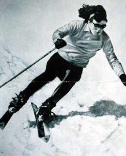
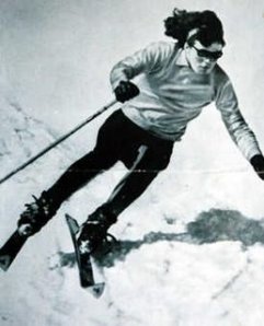
When I posted about Gretel Bergmann and Dora Ratjen, I came across another name from closer to home — Erika Schinegger, who was a shining star in the women’s downhill ski races in the mid 60s. Last night ORF aired a 2005 documentary film about Schninegger — Erik(A) — and the events of 1967, when the Austrian Olympic hopefuls submitted to medical testing by the IOC and it came out that Schinegger was, chromosomally speaking, male.
While Ratjen withdrew from society and never spoke to any reporters about his experiences, Schinegger is congenial and loquacious, as well as a very attractive man. Looking at old photos now, one clearly sees (in restrospect, of course) a young man’s face and body. But many of those interviewed said that they were surprised by the test results. They had assumed that Erika Schinegger was simply a healthy, somewhat homely country girl, with muscles from all that farm work.
Schninegger underwent corrective surgery and changed his name from Erika to Erik, and actually competed successfully on the men’s downhill team for a short time — until the Austrian Ski Federation made him resign, due, they told him, to “unrest in the media” and among his teammates. Schinegger returned to live in the village in Carinthia where he grew up, opened a ski school for children, and eventually married (and fathered a daughter.) If he had any bitterness in him, it was not apparent in the film.

The filmmaker interviewed a dozen or so people; family members, childhood friends, teammates, as well as extensive interviews with Schinegger himself, and pulls a neat trick by juxtaposing archival footage with that of modern teenagers at athletic training exercises. The effect is that you as the viewer begin to look at the girls with a clinical eye, noting the things that make them “feminine” — or not. You begin to both notice and question the “obvious” differences between the genders.
Update: I keep coming back to Caster Semenya and what the media circus last year has done to her life. Schinegger had two big things going for him – one was the time and place, and home being a place where he could go about having a normal life, once the locals adjusted (which they did), the other was that by his own accounts, while he grew up identifying as a girl from not knowing anything else, he tended toward boyish things — he tells of annual Christmas meltdowns as a child, when getting another doll instead of the long-desired tractor (the dolls all got their heads broken eventually!) and evidently was able to settle into being a guy relatively easily. The way he described it, it seemed like a natural progression for him. The contortions that Caster’s family/publicity agent/whoever is putting her through to enforce the idea that she’s a “real woman” can’t be good for her.

>Hofgarten im Winter

>
The Innsbrucker Hofgarten is celebrating 600 years in existence. Established in 1410 by Duke Friedrich IV (“with the empty pockets”), it is an example of the English-style gardens that were copied by monarchs all over the continent (the English Gardens and the park lands behind Schloss Nymphenburg in Munich are further nearby examples.) Its 10 hectares (ca. 25 acres) are right in the center of town, like a miniature Central Park, with a nice café/beer garden, a music pavillion, (a pretty Baroque structure built in 1733 — see photo above) botanical gardens and greenhouses for cactii and palms. It is said that there are specimens within the park walls which were planted by Empress Maria Theresia herself. I don’t know which ones, but I suspect an enormous, rambling old tree with branches that touch the ground and have rooted there.
I have walked these paths many, many times. It’s a lovely, quiet place to breathe in a bit of fresh air and enjoy the leafy views.

>Long Before It Was Tirol, It Was Raetia

>This unassuming, wooded hill hides the remains of a group of Raetian houses from around 400 B.C.
The Raetians were a people who moved into the lands between Lake Garda and the Karwendel Mountains by the 6th century B.C. They are somehow associated with the Etruscans (their exact relationship is disputed, but there are similarities in their alphabets and a possible genetic link has come to light); Pliny the Elder wrote that they were an Etruscan clan driven out of the Po Valley by other tribes.
A technically and spiritually advanced society, they had a high level of technical, architectural and artisanal skills. Raetian wine from the area around Verona was Caesar Augustus’ preferred drink. They raised crops and farm animals such as cattle, sheep, goats and pigs. They kept dogs and horses. They handled in raisins, tree resin, lumber, wax, honey and cheese. They made their own artistically distinct ceramics.
What’s left of their houses are these stone cellars with narrow stair corridors. The entire group was in encircled by a sort of fort wall of sharpened logs, about one meter high (more picket fence than fortress)
Archaeologists have found much metalwork: chisels, axes, blades, iron rings, keys, door and chest handles, hooks. They families that lived here apparently did so in relative comfort, security and prosperity, able to make, trade for, or buy anything they needed.
And, all around, they had quite a view to enjoy —
Also found nearby (but no longer existent) was a temple area with sacrificial altars. In better times the Raetians sacrificed animals and crops to their god(s), and used the fire altars to sanctify bronze jewelry and weapons.
In 15 B.C. the Romans decided to push northward, subjugating the Raetians and burning their villages. The survivors took to sacrificing coins, as everything else was too valuable to burn. And once the Romans forced their culture and language on everybody else, traces of the Raetians dried up.
The cellars are now preserved as a free open-air museum with signs posted giving information about the Raetians and about the archaeological finds, now on permanent exhibit at the Tiroler Landesmuseum in Innsbruck.

>A hike to the Lanser Kopf Flakstellungen

>A hike around the Paschberg, at the southern end Innsbruck. Looking back towards town, the Igler Bahn streetcar winds it way up through the forest to the villages on the plateau on the other side of the hill.
One of the cutest houses around, the Tantegert stop. It’s a little fairy tale cottage along the tram line, and (I believe) inhabited by someone who works for the railroad. It’s nestled in the woods but not very private, with several hiking trails crossing right behind it.
Not a grave, but a little shrine to someone who died at this spot on the hill. You see crosses and plaques like this, as well as tiny chapels, often in the mountains. What makes this one especially interesting is the painting which depicts the manner of the man’s death — it seems he fell, and his sled filled with firewood fell on top of him. I guess. Here’s a close up:

These concrete circles are at the very top of the Lanser Kopf, a rocky outcropping and the highest point on the hill. Remains from the Second World War, they were spots for anti-aircraft guns, or Flak. Did you know “Flak” stands for Fliegerabwehrkanone? As a child of peacetime, I never realized that talking about “getting flak for something” was of military origin, and German at that.

>Alte jüdische Friedhof

>Years ago, walking through the hills along the Inn river, I came across a sign pointing to the “Judenbühel“. It was a half-grassy, half-wooded slope steeply uphill from the river, and aside from a flat hilltop with a playground on it, there was nothing else to help me figure out what the Judenbühel was, exactly. Thanks to the wonders of the Internet, I later learned that it was the site of the old Jewish cemetery, dating back to at least the early 16th century. By the 1860s some problems arose — the new river road made access to the cemetery difficult; in winter it was a steep icy climb to get up there. The lack of access also seemed to have made it easier for vandals to rip out the stones when nobody was around. In 1873 the Jewish community got a corner of the downtown Westfriedhof, the bodies were transferred over, the wall knocked down, and the field left to return to nature.

Today I went walking that way again, and found something new: archaeologists found the placement of the old wall, and the city put up metal plates around the perimeter, with stars of David cut out of the metal. A sign explaining the site includes all the parties involved in the project, including the man who got it going: Innsbruck’s Retired Bishop Reinhold Stecher. There was an official ceremony in July, with speeches made and music performed.(Video here) I’m sorry that I missed the cemerony, but happy to see that the old cemetery grounds finally got a little love from the community.